
3 Lab 3: Biome Detective
Introduction
There are many features at come together to determine the biophysical environment, including soil characteristics, flora, fauna, water availability, and climate. Each of these features directly and indirectly shapes the others, but arguably, the climate of the particular region plays the largest role. Climate is typically shaped by the factors that control temperature and precipitation, which include: latitude, insolation of solar radiation, elevation, proximity to large bodies of water, ocean currents, and land use/land cover. We spent last lab observing the weather, and drawing comparisons to the local climate. Today, we will be using climate data and visualizations of the biophysical environment to further solidify our identification and understanding of major biomes. Recall, we have discussed 8 major global biomes:
1) Tropical Rainforest, 2) Savanna/Tropical Dry Forest, 3) Desert/Semi-Desert,
4) Mediterranean, 5) Temperate Grassland, 6) Temperate/Deciduous Forest,
7) Boreal Forest, 8) Tundra
The primary objectives for today are to:
- Analyze/comprehend climographs from various locations, to grasp the climate of the area
- Use the climographs, plus visual cues, to determine the biome of a particular region
- Gain a geographic perspective as to where specific biomes are located on the planet
Background Information/Further Reading
GEOGUESSR
For this lab, we will be utilizing the online platform GEOGUESSR. This is a free platform that utilizes Google Maps – Street View. The platform works by effectively dropping you somewhere in the world, then you get to roam around on street view, looking at various visual clues to determine where you are. The game is generally considered fun, and potentially addicting.
To use the specially-created maps for this lab, you will need to create an account on Geoguessr.com. It is no-cost, and relatively painless. You do NOT need a pro account. To save time in lab, please create your account prior to lab! There will be a specific link provided to you, which are for predefined locations that you will need to investigate. You are encouraged to practice using the platform the day before lab. Only one game can be played per day for free. Consider starting with “Omaha Metro, NE, USA”: https://www.geoguessr.com/maps/5cf6940b19e12f3474502621
Climographs
Climographs are graphical representations of typical climatic conditions for a specific location. We’ve used some in lab 2 to compare with our meteorological observations. In this lab, two variables will be depicted on each climograph: temperature and precipitation. For both variables, average monthly conditions are shown over the 1980-2010 period. Months are on the x-axis: 01 = Jan, 02 = Feb, etc., while temperatures and precipitation magnitudes are on the y-axes.
Average temperatures (in °C) are shown as lines, while the bars show precipitation accumulation (in mm). With them, we can determine a number of critical insights, including temperature and precipitation range, warm/cool/dry/wet seasons, a likely tropical/temperate/polar distinction, and others.
Below is an example of a climograph. We can see that the average daily temperature (red line) throughout the year is highly variable, ranging between 25°C in the summer to below freezing in the winter. Precipitation (blue bars) also is seasonally variable, with larger amounts of precipitation in the warm season (May-Sept), and lesser amounts in the cool season (Oct-Apr).
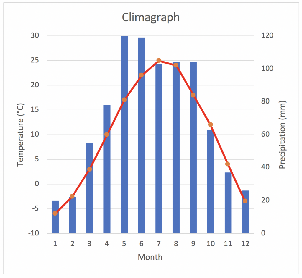
Because the temperature does vary with the seasons, with only a few months of the year below freezing, we can assume it is a middle-latitude location. The magnitude of temperature variation also indicates a likely in-land, or continental, location away from the influences of Oceans. There is a relatively-dry season during the winter. Putting the temperature and precipitation together, we might hypothesize this is a temperate grassland or temperate forest biome.
Questions
Part 1 – Climographs
1. You will be provided climographs for seven different locations within the United States. Your first task is to describe the characteristics of the climate for this location. This could include information such as:
- The magnitude of temperature variation during the year (annual range)
- Average annual temperature (i.e. tropical, polar, or midlatitude)
- The amount of precipitation (including a general distinction of wet, dry, or variable)
- The timing of precipitation (consistent all year, dry season, wet season)
- Other information you find appropriate
Climograph A:
Climograph B:
Climograph C:
Climograph D:
Climograph E:
Climograph F:
Climograph G:
Part 2 – Geoguessr
Instructions: You will be playing a game of Geoguessr for this part. You will be randomly given five locations in the United States that will match five of the seven locations of the climographs. Once you start the game, your first step will be to take a few notes about the first location. Pay specific attention to the biophysical environment, noting things such as: quantity and types of vegetation (evergreen vs. deciduous trees, shrubs, grasses, no vegetation, all the same type vs. mixture, etc.), and the color and texture of the soil (if possible). You should also take note of any other distinguishing features such as bodies of water, mountains, or man-made features.
Once you have described the location, go ahead and make a guess as to where your location is located, using the Geoguessr map, and write in the general location on this lab (nearest city, state OR lat/lon). You’ll also be recording the correct location and how far away you were. Keep in mind, all locations are in the U.S. for this activity. Many locations within the same biome across the US exist. Think logically and don’t panic if your answer seems REALLY far away. The link to the specific location is: https://www.geoguessr.com/maps/5cf6a503b741f87ce8ce3adf alternatively, you can search “GEOG1050 – Biome Detective, USA”. As noted in the name, only locations in the USA are options.
2. Fill out the table below, following the directions given above.
|
Location |
Description |
My Location Guess |
Correct Location |
Distance away |
|
1
|
|
|
|
|
|
2
|
|
|
|
|
|
3
|
|
|
|
|
|
4
|
|
|
|
|
|
5
|
|
|
|
|
|
Game Summary, Total Points:
|
||||
3. At this point, you have seen all seven climographs. You’ve also seen five of seven possible correct locations in Geoguessr. The climographs’ locations roughly match the locations used in the Geoguessr game. Your last task is to determine which Geoguessr locations (i.e. question 2) correspond to which climographs (i.e. question 1). You should be able to match five of seven fairly precisely based on your answers to question 2. For the two remaining climographs for which you do not have specific locations from Geoguessr, make an educated guess.
Climograph A: ___________________________
Climograph B: ___________________________
Climograph C: ___________________________
Climograph D: ___________________________
Climograph E: ___________________________
Climograph F: ___________________________
Climograph G: ___________________________
